articles/Review/gps-page6
GPS – Finding your way to that perfect landscape location - part 6 of 1 2 3 4 5 6 7 8 9 10 11 12 13 14 15 16
by Mike McNamee Published 01/02/2017

Cyclestreets.net
Formerly the Cycle Touring Club (CTC) but changed to Cycling UK in 2016, they provide an excellent route planner for cyclists based upon open source mapping. It allows for calculation of the shortest, quietest or balanced routes using cycle ways where possible and rating the safety of the route used. It lacks the ability to plot a circular (out and back) route which has to be fudged with two attempts. The mapping/view choice is from OSMCycle, OSM, OS Open Data, Google Maps, Google Aerial or Bing Aerial. OSMCycle shows vertical contours, OS Open data gives detail to house level and Bing Aerial is in a different (better) class than Google Aerial. You can export GPX files with waypoints which Garmin failed to recognise.

Ride with GPS
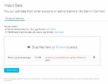
This seems to be one of the best we looked at; it mentions Garmins a lot but not the 820! There is an extensive explanation of the differences between the types of files that you can export. The main two are '.gpx' files and 'TCX Course files'. * We exported both types of file to the Garmin 820 and neither became available on the device.
* There are two versions of TCX files: TCX Course and TCX History. TCX stands for Training Centre Database and is a Garmin schema for XML. TCX Course files contain all the navigation to use with your Garmin Edge series devices. This is the most common file format that we recommend to get turn-by-turn navigation.
Please Note:
There is more than one page for this Article.
You are currently on page 6
- GPS – Finding your way to that perfect landscape location page 1
- GPS – Finding your way to that perfect landscape location page 2
- GPS – Finding your way to that perfect landscape location page 3
- GPS – Finding your way to that perfect landscape location page 4
- GPS – Finding your way to that perfect landscape location page 5
- GPS – Finding your way to that perfect landscape location page 6
- GPS – Finding your way to that perfect landscape location page 7
- GPS – Finding your way to that perfect landscape location page 8
- GPS – Finding your way to that perfect landscape location page 9
- GPS – Finding your way to that perfect landscape location page 10
- GPS – Finding your way to that perfect landscape location page 11
- GPS – Finding your way to that perfect landscape location page 12
- GPS – Finding your way to that perfect landscape location page 13
- GPS – Finding your way to that perfect landscape location page 14
- GPS – Finding your way to that perfect landscape location page 15
- GPS – Finding your way to that perfect landscape location page 16
1st Published 01/02/2017
last update 21/07/2022 08:49:43
More Review Articles
The Society of Photographers Convention and Trade Show at The Novotel London West, Hammersmith ...
You have 0 days until The Society of Photographers Convention Wednesday 14th January 2026


