articles/Review/gps-page14
GPS – Finding your way to that perfect landscape location - part 14 of 1 2 3 4 5 6 7 8 9 10 11 12 13 14 15 16
by Mike McNamee Published 01/02/2017

OVERVIEW
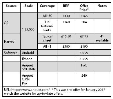
The experience has been chastening! The initial dearth of information from what appeared to be reasonably well-constructed search terms was a bit of a surprise. Once we had unravelled that conundrum (which only took 18 days of obsessive geeking!) we suspect that some of the user issues arise from Ordnance Survey. There is a philosophical argument which says that, in regard to OS, their output is publicly funded information and should be freely available. Like so many cashstrapped 'public services' OS has spotted a cash cow which it seems to be resolutely milking, despite the availability of free milk from the likes of Open Street Map – indeed OSM seems to have an almost anarchic zeal to sideline OS! The cost of maps, on top of the cost of a GPS device always comes as a shock. In truth , though, the cost of the maps is trivial compared with the cost to the landscape photographer of getting to remote Highland locations. For the record, the map costs from the Anquet website are tabled.

The user frustration arises from the lack of interoperability – can you imagine buying a new DSLR only to find that its JPEG output could only be read by the manufacturer's bespoke software and was not viewable in Photoshop, Elements, Word, Corel, or any web browser, etc, etc? XML, the base code for all GPS, is both simple and universally understood – even your editor can look at the code and see what is going on so why is it all such a PITA for goodness sake!
Please Note:
There is more than one page for this Article.
You are currently on page 14
- GPS – Finding your way to that perfect landscape location page 1
- GPS – Finding your way to that perfect landscape location page 2
- GPS – Finding your way to that perfect landscape location page 3
- GPS – Finding your way to that perfect landscape location page 4
- GPS – Finding your way to that perfect landscape location page 5
- GPS – Finding your way to that perfect landscape location page 6
- GPS – Finding your way to that perfect landscape location page 7
- GPS – Finding your way to that perfect landscape location page 8
- GPS – Finding your way to that perfect landscape location page 9
- GPS – Finding your way to that perfect landscape location page 10
- GPS – Finding your way to that perfect landscape location page 11
- GPS – Finding your way to that perfect landscape location page 12
- GPS – Finding your way to that perfect landscape location page 13
- GPS – Finding your way to that perfect landscape location page 14
- GPS – Finding your way to that perfect landscape location page 15
- GPS – Finding your way to that perfect landscape location page 16
1st Published 01/02/2017
last update 21/07/2022 08:49:43
More Review Articles
The Society of Photographers Convention and Trade Show at The Novotel London West, Hammersmith ...
You have 0 days until The Society of Photographers Convention Wednesday 14th January 2026


